Luthersburg/Brady Township
EARLY SETTLERS
The original settlers of the Brady Township area were the Pennsylvania Dutch. Lebbeus Luther, for whom Luthersburg was named, was born on March 22, 1792, in Massachusetts, and came from Bradford County to Oldtown (now Clearfield) in 1813. He became a local agent for the real estate firm of Fox and Company and sold much of their holdings in Brady Township for which Luther paid $5 per acre for 140 acres.
Benjamin Bonsall, who came from Perry County in 1824, bought the first tract. Frederick Zeigler came from York County about the same time and settled near the Indian spring. The first pioneer settler in the township was James Woodside in July 1785. A monument in his memory is located in Luthersburg’s Union Cemetery.
Other early settlers included Jacob Kuntz and George Elinger in 1822; John Carlisle in 1828 or 1829; Adam Knarr in 1826; and the Weisgarbers, Wingerts, Korbs and Yoes in 1831. Jacob Troutwein, after whom Troutville is named, arrived in 1832. John Kirk and David Welty came in 1832, John Potter in 1834, Henry Goodlander and John Pentz in 1837. Many of them were “squatters” but gained title to the land by peaceable possession for 21 years.
THE TOWN OF LUTHERSBURG
Brady Township was officially organized in 1826. A road from Luthersburg to Troutville (Route 410) was completed in 1831, and in 1835, Luthersburg was laid out as a town.
In 1883 Luthersburg boasted three general stores, a hardware store, a tin shop, a harness shop, a livery stable and an undertaking business. There were two blacksmith shops, three cobblers, two confectionery stores, a dry goods store, a squire’s office, a barber shop, a lodge hall and many other general stores. Men could belong to the Mingle Lodge, Independent Order of Odd Fellows.
In 1824 Mathew Irvin came to Luthersburg and opened a store but did not erect the actual building until 1827. Mathew Irvin bought the first two lots and was first taxed for them in 1831. Three years before this time, Irvin built the first frame barn in the township.
The highest point in Brady Township is the Luthersburg “Knob,” locally known as “Cream Hill,” which has an elevation of two thousand, sixty feet, or about two hundred feet higher than the village of Luthersburg and about six hundred and sixty feet higher than the City of DuBois.
FIRES
On November 15, 1889, a fire destroyed many buildings in town, on the north side of Route 219 and 322. The fire broke out about 4:30 p.m. in Dr. Gregory’s carriage shed. Without a hose company and fire hydrants, the citizens formed bucket brigades to contain the flames to one side of the street. In addition to six businesses and several homes, everything between Schwem’s Hotel on the east and Goodlander’s store on the west was destroyed. Property loss was estimated at $19,000.
A fire on March 4, 1943, almost destroyed the old Moore building, then occupied by the post office and the telephone exchange. DuBois Volunteer firemen assisted in dousing the fire, limiting the loss to a few hundred dollars.
On November 1, 1961, a rupture of a main gas line occurred at the New York State Gas Co. offices and warehouses, located on Route 322 and 219, a quarter of a mile west of Luthersburg. The large fire could be seen for miles and caused over $300,000 in damages. It completely destroyed the gas company’s offices, garage, and 18 of its vehicles.
It was not until 1958, 69 years after the fire of 1889 which partially destroyed the village of Luthersburg, that the Brady Township Fire Company was formed.
CHURCHES
The first religious services in Luthersburg were held in the barroom of the Cream Hill Hotel by Reverend Anderson in 1822 or 1823. In 1826, a young Methodist circuit rider named Davis Kinneson visited Luthersburg and preached in the log schoolhouse built that year on the location of the cemetery. Rev. Kennison went on to organize the first Methodist Society in the Luthersburg Charge in 1827 in a barn one-fourth mile west of the town. In 1841, a church building was begun on land that is now part of the Union Cemetery. A parsonage was built in the summer of 1883, when membership was about eighty-five. Rev. J. W. Spangler was the minister.
A new church structure was started in 1871 which measured 45-feet-by-75 feet. It was built at an estimated cost of $5,600. A 600-pound cast iron bell was placed in the belfry. In 1956, the decision was made to replace that building with a new one. Consecration services were held in the new brick structure on September 29, 1957. The total cost for construction, $51,238, was paid in full when it was dedicated on September 18, 1960.
The first church in Luthersburg was a Lutheran church built in 1845. It was the first church of that denomination constructed in the county. St. Peter’s Lutheran Church congregation built a wood frame building in 1844. On May 27, 1883, the cornerstone of the current building was laid and was dedicated on November 18 of that year. Statistics in the church’s Anniversary Book state that the building was 40 x 60 feet and had a 94-foot steeple. This steeple was struck by lightning in the 1920s and was replaced by a shorter one. The original cost of construction was $5,000.
St. Luke’s United Church of Christ was organized in April 1891 when a group gathered at the home of David Reams to discuss purchasing land for a new church. Until that time, it had been part of a church located between Luthersburg and Troutville. The cornerstone was laid on August 9, 1891, and the dedication service held January 31, 1892. In 1893, more land was purchased to create a cemetery to be located behind the church. A new Sunday school building was dedicated on June 30, 1974.
SITES AND MARKERS
Approximately .3 mile southwest of Luthersburg on Route 410 is a marker denoting the site of the Indian Trail known as the Mead Brothers Trail. One mile south of the marker on 410 is the Indian Spring and Indian Campground which was used by Major George McClelland and his army in the War of 1812. Approximately 2.2 miles southwest of Luthersburg on Route 410 is the memorial marker dedicated to the Trinity Reformed Church, which was erected in 1853.
Lebbeus Luther built a hewn-log tavern at the intersection of the Rockton and Grampian roads, near where the Daughters of the American Revolution marker now stands, and named it “Cream Hill Hotel.” When the pike was finally completed in 1824 and a stage line was started by Robert Clark, the tavern became a busy place. Conestoga wagons, drawn by four or six horses and bearing three to four tons of freight, could be seen at Luther’s tavern. Drovers, cattlemen and peddlers also stopped there. As many as sixty iron sleds might be parked at the tavern, on their way to the Clarion River from the furnaces in Centre and Huntington counties. Shipment was made down the river in barges and rafts to Pittsburgh and other western cities along the Ohio River. The photo above, taken the day of its dedication, shows the marker for Luther’s hotel.
HOTELS
Once Lebbeus Luther relocated to Ridgway, the tavern business fell to two owners at two different locations. Little is known of these early ventures, but the stages chose the hospitality of George Long, who was located across the road from the D.A.R. marker. This establishment was later acquired by William Schwem, Sr., in the 1850s and was known as the “Eagle Hotel.” Later, his son, Charles Schwem, became proprietor. Finally, in January 1901, H. M. Carlisle bought the hotel, obtained a license, and installed acetylene lights. The Aricks operated the hotel for a time before it was finally dismantled.
The other hostel was “The Golden Yoke.” This hotel (above) was built in 1863 by Robert W. Moore to accommodate the heavy stream of traffic over the pike. After passing through numerous hands, the property was eventually acquired by Daniel Goodlander, a wealthy farmer and merchant. His scruples against alcohol led him to discontinue the taproom and to name it the “Temperance House.” The building was subsequently converted into a private home, but was reopened to the public in 1946 by Arthur and Harold Miller as an eating place under its former name. In 1952, Mrs. Charles Wingert of Brookville assumed the proprietorship.
HUNTING
Game was so plentiful that Adam Knarr counted 30 deer in a four acre field. Frederick Zeigler killed over 600 deer in his time, then lost count, and shot many more. He also killed or captured 82 bears. Mrs. David Haney had a unique reputation of being able to scold wild animals. On one occasion the wolves attacked her cattle while she was alone in her cabin and she scolded them until they ran away.
WATER SYSTEM
A feasibility study of a public water system began on December 7, 1964. On February 8, 1968, the first meeting of the Brady Township-Troutville Borough Municipal Authority was held. On January 9, 1969, this organization was changed to what is now known as the Brady Township-Troutville Borough Water Association. In April 1972, water was provided to citizens of Troutville, and in July 1972 Luthersburg citizens received water.
POST OFFICE
Brady Township was organized in 1826 and the first post office at Luthersburg was kept by David Irvin in 1824. The first Post Office, “Luthersburgh,” opened July 10, 1830, and became Luthersburg without the “H” on December 1, 1894. The first postmaster was G. Hoover, according to “Pennsylvania Postal History” by John L. Kay and Chester M. Smith, Jr.
BUSINESS AND INDUSTRY
The first tannery was built by Benjamin Bonsall on the left side of the pike going east, but the operation was not a financial success and was abandoned a few years later.
Another industry which was started around 1840 was a pottery factory by Robert W. Moore and Ira Fisher, located about a mile east of Luthersburg on the Rockton road. They manufactured what was known as red ware in a round log building until 1842 when the business was sold to Taylor and Teats. Although it passed through other hands and in other locations, the pottery business persisted in Brady Township throughout the remainder of the century. Stoneware was made after 1853.
MEDICAL SERVICES
The pioneer physician in Luthersburg was Dr. George Wilson, who had no professional schooling. He learned his methods studying under Dr. Dowling of Brookville, then practiced for five years in Big Run and two years in Grampian before coming to Luthersburg in 1846. He remained there the rest of his life.
Dr. R. V. Spackman, a native of Centre County, moved with his parents at the age of five to the Spackman farm near Curwensville. He spent ten years studying medicine under Dr. Woods of Clearfield and at the Jefferson Medical College, from where he graduated in March 1864. He bought his home in Luthersburg in 1868 and built an office in 1870.
SCHOOLS
A log schoolhouse was built around 1825, with Whitson Cooper as the first teacher.
In 1907, a three-year high school course began. In 1908, a one-room building known as the Brady Township High School was constructed. The first class of four girls graduated in 1910: Lillian Pentz, Lillian Kirk, Elizabeth Campbell and Lily Weisgerber.
Today a modern elementary school for kindergarten through fifth grades exists. Luthersburg is part of the DuBois Area School District. The two former schools that sit on a hill overlooking the town are now owned by Brady Township, connected by a hallway and remodeled, now used as a Community Center.
TIDBITS
A local Luthersburg belief is that James Woodside’s ghost left a secret cave at midnight, July 29 th, of each year and prowled around the neighborhood.
Brady Township
This township was named in honor of Captain Samuel Brady, a noted Indian fighter and a mighty hunter. The township was organized in 1826 and is situated in the northwest corner of the county and about 2000 feet above the sea level.
It is bounded on the north by Sandy Township on the east by Union and Bloom Townships, on the south by part of Penn Township and Bell Township and on the West by part of the dividing line between Jefferson and Clearfield Counties. The surface is somewhat hilly with a gentle slope to the westward and there are many excellent springs, some of which are mineral. There is considerable coal development in the township but the principal business of its inhabitants is agriculture. Much valuable timber was destroyed in the process of clearing the farms. The population, according to the census of 1910 was 2823. The township is traversed by the B. R. & P. and the B. & S. Railroads.
The first white settler of this township was James Woodside, a native of Chester county, Pa. He located on a tract of land situated on the head waters of Stump Creek, which was surveyed to him in July, 1785, which was known as the “Woodside” and later as the Luther place. Here for twenty-two years he had no neighbors but the Red men of the forest. He was then cheered by the advent of a new white settler, Joab Ogden, who located a mile further down the creek—this was in 1807, on the spot which afterwards became the site of Carlisle station on the B. R. & P. Railroad.
In 1812 George, Michael and Frederick Scheffer settled on Sandy Lick Creek, George locating on land that is now a part of the site of DuBois. Fred and Michael located a few miles further up the creek.
James, Benjamin and Thomas Carson came in 1814. In 1820 Lebbeus Luther, a native of Massachusetts, bought and settled on a tract of land located where Luthersburg now stands, the place being named after him. He was appointed by Messrs. Fox & Co., who owned thousands of acres in this section, as agent to dispose of their lands. He made his first sale to Benjamin Bonsall, who came from Perry county in 1824. About this time also Frederick Zeigler, came from Center county and settled on what was later known as the “Thompson” place. Mr. Bonsall was appointed first justice of the peace after the organization of the township in 1826.
John Carlisle, who came from Lebanon county, was another settler on the site of Luthersburgh.
In 1830 Jacob Kuntz, a native of Germany, settled near where the Reformed church was later erected. The year 1831 saw the advent of the Knarrs, Weisgerbers, Wingerts, Korbs, and Yoases, Jacob Trautwein coming in the following year. These settlers were soon followed by many others, whose names we have not space to record. Many of these early settlers “squatted” on land—that is, took possession of it, without knowing to whom it belonged, and by keeping undisputed possession of it for 21 years became the lawful owners.
The first mill in the township was Ogden’s (near Carlisle Station). Two famous hunters among the early settlers were Fred Zeigler and “Uncle Billy” Long. Another excellent marksman was Lebbeus Luther. All these men could tell great hunting stories and, as game was exceedingly plentiful, did not have to draw much on their imagination, as modern Nimrods are so often accused of doing.
Luthersburgh was the first post office established in Brady township, dating back to the completion of the turnpike about 1820. David Irvin was the first postmaster. Troutville post office was established in 1857 to 1858, the first postmaster being Jacob Kuntz. The town had been laid out three years previous to this time, and was named, it is said, by Rev. John Reams, in honor of Jacob Trautwein, the name as finally adopted being a contraction of Trautweinville, which was found to be inconveniently long.
Joab Ogden built the first grist mill in the township, some time previous to 1830, though the exact date is not now known. About 1849-50 Jacob Kuntz built a grist mill on East Branch (of Mahoning) a mile and a half south of Troutville; this was later known as Risliel’s mill. In 1854 Jeremiah built a steam and water-power grist mill on the head waters of Stump creek, two wiles west of Luthersburgh. It was subsequently operated by his son Samuel, and afterwards passed through various hands.
The first saw-mill was built, it is said, by Fred Zeigler between 1824 and 1830, Jesse Line’s saw-mill being subsequently erected on the same site. The second saw-mill was built by Jeremiah Miles, it being later known as Zeigler’s mill.
The first minister who preached in Brady township was a Rev. Mr. Anderson, who came about 1822, and held servicesjn the bar-room of Luther’s tavern. He was a Presbyterian. In 1827 came Rev. David Kennison, being sent by the Baltimore conference of the Methodist Episcopal church; he also preached in the tavern at Luthersburgh. About the same time came Rev. John Althaus, a Reformed minister from Armstrong county, who made occasional visits preaching to the German settlers. These early pastors and others who soon followed them were the men who organized the religious element of the township and laid the foundation of the moral and religious development and thriving church societies that exist today in the township, and which in Union with good schools, have had so much to do in moulding the character of its inhabitants.
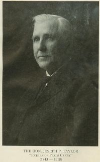
Falls Creek Background
Falls Creek was founded in 1848, but it was not until years later that Joseph Taylor (1843-1918) and Sidney Fuller were responsible for much of its development.
The first settlers arrived in the Falls Creek area in 1824 and Falls Creek Borough was established of Washington Township in Jefferson
 County in 1839.
At its conception, Falls Creek was divided into two communities, known as Falls Creek and Evergreen. When an application was made for a post office, it was learned that there was another community in Pennsylvania named Evergreen, so the name was changed to Victor.
Until this time, residents of Evergreen were required to pick up their mail at the Rumbarger (DuBois) office. In 1889, when J.F. Reed was named postmaster, the community was officially rechristened Falls Creek.
In 1890, Taylor and his brother-in-law, Fuller, laid out the streets. Taylor is credited with luring Thomas Proctor to build a tanner in Falls Creek in 1891 and other stores and businesses followed.
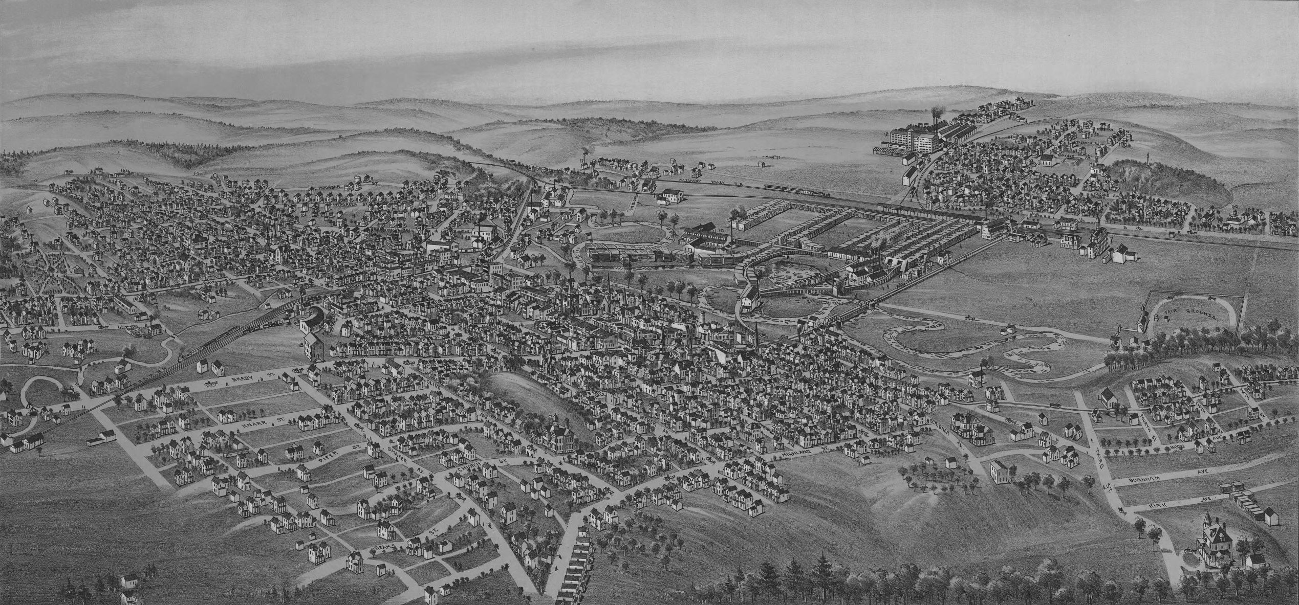
Since at that time the railroads were bringing hundreds of men to the area to help ship coal to all parts of the country, the pioneer residents envisioned that the growth of the town would be centered around its busy railroad crossing, which was established in 1883 with the completion of the B.R. & P.R.R. and the crossing of the Allegheny Valley Railroad a year later.
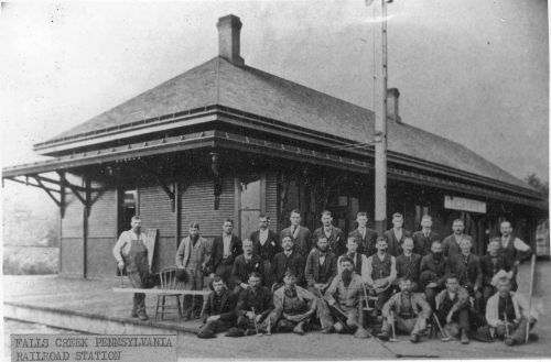
The pioneer residents of the community envisioned that the growth of the town would be centered around its busy railroad crossing, which was established in 1883 with the completion of the B.R. & P.R.R. and the crossing of the Allegheny Valley Railroad a year later. The train station hosted all of those arrivals and stood until the early 1980s when it was demolished.
With the construction of a two-story brick store and residence built by Mr. J. L. Reed to spur grown, other homes quickly followed and the town was named Evergreen. A large, four-story hotel, the Lamontague, was erected at the corner of Main and First Streets and provided porches with easy seats from which to view the crowded streets each night. Until it burned down nearly a dozen years later, the Lamontague was the center of activity for the community. Two other hotels served the town during its boom days, the Emory on Main Street and the Casey House on Taylor Avenue. It was not until 1890 that streets were laid out and tree stumps finally cleared from the land. A few houses and stores stood along the street lines, but in rainy weather, rubber boats were required to reach them.
In the late 1800s, Falls Creek prospered with its lumber yards, saw mills, glass plants, tannery, brick plant, and a huge stone quarry, and seemed to be surpassing DuBois in population and size. A new road to DuBois was planned, and with the tannery working at full employment, prospects were bright for continued expansion in that part of town. Although a new water supply and sewage system were planned and a number of new homes were erected on Jefferson Avenue, the feverish boom across the creek in Jefferson County seemed to rob the new division of its initiative.
In April 1892, G. B. Daughtery arrived in the area and, with Ulrich Matson, erected a brick plant. With clay and sand products readily available, the company expanded its operations and became one of Falls Creek’s major industries over the years. One of the largest industrial plants which the area attracted was the Proctor Tannery. Its building covered over 25 acres and received shipments of hides from all over the world, including Texas, Mexico, and Argentina. It was stated that the Falls Creek tannery was the largest in the world, with 1,000 hides being shipped to the plant each day.
The first glass company was built in 1897 by a Mr. Stouffer, and it covered about three acres. In 1899 it was purchased by Ralph Gray and his son, George. The company manufactured specialty glass for many years, then stood idle for some time. In the mid-1930s, it was purchased by the Gray Printing Company.
The huge Fitzpatrick Window Glass Factory was built in 1900 at a cost of over a million dollars, near the site of the later Jackson China Company. This company brought in a small army of glass workers. The plant touched off a new boom in the town with hundreds of visitors attracted to the swing of the single and double strength cylinders of molten glass. The company had its own sand quarries and with excellent rail facilities available in both the R.B.R. and P.R.R., prospects for the industry and town were extremely bright.
One of the great builders of Falls Creek was Mr. G. A. Gocella. The town was founded on great layers of sandstone, and during the next half century, huge quantities of building stone and crushed stone were used in railroad construction and bridge work. Mr. Gocella was one of the first to exploit these fields and provided stones for not only railroads throughout the east, but also for many contractors in the expanding building operations. The Gocella Mansion remained as a landmark for many years.
After the discovery of a process to make window glass by machinery, the day of the hand-operated glass plants was over. In 1914 the Fitzpatrick plant was taken over by the DuBois Glass Company, and shortly thereafter was sold for junk. When the cement age arrived, the town suffered a great blow. Railroads, industry and building contractors substituted less expensive cement for the more costly stone product.Criminal Activity
Falls Creek was a hangout for some of the worst gangs of criminals in the state. Shortly after the Civil War ended and prior to the coming of the railroads, a string of unfortunate events occurred. One took place a few miles from town at the old “Billy McDonald Farm” and which was later to be known as the “Old Haunted House.”
At about the time the Old Osborne Mill was constructed, an old hunter named Tommy Moore built a shack on this farm and shortly thereafter, committed suicide. Later, an old Scotch Highlander named William McDonald tore down the shack and built a superior log cabin. One day he knelt down beside a log and the spot once again claimed a life.
Mrs. McDonald lived alone for several years, but with the end of the War a number of unsavory characters had drifted into the backwoods. Two of these men were named Chase and Graves, and when they learned of a sum of money Mrs. McDonald had in her possession, they broke into her cabin and killed her. Both were captured and Chase was hanged in Brookville in August 1867. Graves served an extended sentence in the penitentiary. It was the beginning of a long series of criminal activity.
Many stories are uncredited. It was said that horse thieves in Clarion County ran their horses into the area, colored them and sold them elsewhere.
It is also said that one day two brothers by the name of Benson got drunk and tackled a big Swede at his backwoods. The Swede defended himself with an axe, and mangled one of the brothers. Although the Swede brought him to a doctor in DuBois, it was too late, so he went on down the street and dropped him at an undertaker. It was not an easy life in those early days.
By the early 1900s, murder and theft had become so common that most men went around armed. One day a Pittsburgh paper carried the headline, “Carnival of Crime in Falls Creek.”
For weeks, a notorious band of criminals known as the “Benson Gang” terrorized this part of the state. They murdered a policeman in Lock Haven, then returned to this area and murdered a Civil War Vet named Capt. W. J. Leahy. A posse was quickly formed and started to comb the town for a group of four men. It was said that Fred Covert was standing at the corner of Main and Third Street in the early morning hours when he heard shots up the street. He then saw three men carrying a fourth up Short Street toward the planing mills. Additional shots were fired but the men managed to make their escape.
The next day, a small boy by the name of Willie Larkey discovered the hideout of the men in the dense undergrowth across the tracks near the depot. He notified the police and soon the posse had surrounded this place, armed with everything from old Civil War muskets to brand new hunting rifles. One man managed to escape, but two other members of the gang were captured and sent to prison for terms of twenty years each. It was later learned that this was the same gang that had killed the Lock Haven policeman.
With the closing of the tannery and police clamping down on freight hopping, the crime wave simmered down, and the “Outlaws Hangout” became a thing of the past.Music
The tannery had its own band of musicians led by Nick Leonard.
There was the Falls Creek Coronet Band, under the direction of Howard Stratton. Another drum corps, headed by members of the Schmitt family, also participated in all holiday parades.
James Lukehart was the Drum Major of the Coronet band and he is said to have worn a suit decorated with four rows of shiny brass buttons. On his head he wore a large bearskin shako, with a large golden eagle dangling from the apex. He was a large individual with full whiskers, and when he led the band down the parade route with his whirling baton, he received cheers from the crowds.
Reynoldsville History Briefs
Reynoldsville borough was originally an Indian village. The last Indians to leave were the Johns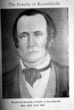 who were still around in 1824.
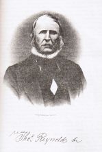
In the 1830s, the men that came to be the founders of Reynoldsville packed up all their belongings and moved from opposite sides of the state and settled in Winslow Township. Thomas Reynolds, Sr.(right) lived about two miles east of what is now Reynoldsville but he owned all the land in what is now the eastern portion of the town.
 Woodward Reynolds (left), no relation to Thomas, bought all the land that is now the business portion of the town and lived here. Woodward married Amelia Ross from Kittanning. Their son David was born in 1837. David was the first white (non-Indian) child born in Reynoldsville.
Thomas Reynolds suggested that the place be called Reynoldsville, and in 1850 this suggestion was confirmed by the Post Office Department.
First Utilities
The first telephone was put into service in Reynoldsville in 1882. The Bell Telephone Exchange was established on February 15, 1892. Gas was first put in on April 8, 1890. The pipes were laid from the northern part of Jefferson County in 1889.
Coal
Reynoldsville experienced great growth during the coal mining era, since it was in the center of the coal mining region of the county. About 1847, Woodward Reynolds opened the first coal mine not only in Jefferson County, but in this section of the state. It was closed about 1878. The mine was located in a little hollowÑsouthwest of where Reynoldsville Cemetery is and a short distance south of the Punxsutawney Road.
The Diamond Coal Company was the first to market mined from Jefferson County. The mine furnished the principal industry of the town, and William Sharpe, the pioneer of this coal region, deserves the praise for the first development of the bituminous coal region of Reynoldsville. In 1873 Diamond Mine was opened, located on the south side of the Sandy Lick Creek north of Reynoldsville. In April of 1874, the first shipment was sent by railroad and went out of Jefferson County. It was the beginning of coal shipments from this region to distant markets.
The Powers-Brown Coal Company and the Hamilton Coal Company were both organized circa 1878. In 1885 the firm of Bill, Lewis and Yates of Buffalo, New York, bought the holdings of the Hamilton Coal Company and the Powers-Brown Coal Company in Winslow Township. In 1887 this firm became a chartered corporation and was known as The Bell, Lewis and Yates Coal Mining Company.
The Big Soldier Run Mine, which belonged to this company and opened on October 1, 1889, was at one time considered the largest bituminous coal mine in the world. Its output for years ranged from 500,000 to 2,000,000 tons of coal per annum. The first coal mining machine put in this region was a Harrison allowing coal began to be taken out of the western openings of the mine by a system of wire rope. Before that time, they used mules. The first electric haulage in the mines in the township was in 1903.
Lumber
In the beginning, most of the business and social life in Reynoldsville was dependent on the stage coach and its traffic. But after Sandy Lick Creek was cleared of overhanging trees and debris, the major industry became lumbering. The first large saw mill was near Reynoldsville and known as the Smith Mill. It was built in 1865 and was located on Sandy Lick Creek, a mile and a half below the town. The trees would be cut down and then floated down the Sandy Lick Creek, the Red Bank Creek, and then the Allegheny River to Pittsburgh. One of the first and largest lumbering and rafting operations was run by Charles H. Prescott (for whom Prescottville is named).
Industry
The first industry was a tannery started by Thomas Reynolds. Erected in 1845 and located between Jackson and Tenth Streets, it ran until the end of the Civil War. In 1860, John Reynolds, second son of Woodward Reynolds, introduced the planing mill as well as sash and door manufacturing on the corner of Main and First Streets. The first steam whistle in this section of the country was used in 1870, when one was placed in the planing mill at First and Main Streets.
Churches
In the first few years of Reynoldsville’s existence, religious services were only held occasionally. An old house on East Main Street, afterwards remodeled and occupied by Milton Coleman, was often used for the purpose of holding religious meetings. On one occasion, about 1852, the floor gave way, dropping the congregation to the basement. It is said that five people died in the accident which was augmented by the fire from the over-turned stove.
Many of the religious denominations were active. In 1873, the Presbyterians built a church in what is now Snydertown and in 1870 they formed a church on Main Street. The Catholics also built their first church in Snydertown. Their present building was erected on Main Street in 1884. Prescottville was the site of the First Baptist Church where the congregation was organized about 1858. In 1887, they started the construction of their present building on Main Street. In 1874, the Methodists organized in Reynoldsville, building their first church in 1879. The Lutherans organized here in 1880, building a church on Jackson Street four years later. In the latter 1800s, the Episcopal services of the church organized in Reynoldsville by that denomination in the spring of 1887 were held. In recent years the Christian Missionary Alliance Church was located at the corner of Grant and Third Streets.
Schools
The first schoolhouse in this locality was a little log structure built in 1836 on the hill above the former flouring mill in Prescottville. It was known as the Fuller Schoolhouse and one of the teachers was Thomas Reynolds. A few years later, another schoolhouse was built in Cold Spring Hollow, which was in constant use until 1874, when it was sold. The large school building on central Main Street was built in 1875.
In 1876, a large eight-room, two-story structure was built and used for the next 20 years. In 1896 a brick schoolhouse was erected on Main and Grant Streets, with an addition in 1924. In the early 1950s Winslow Township merged with Reynoldsville Schools and bussed all pupils to Reynoldsville for their education.
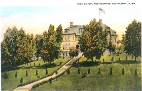
Reynoldsville High School
Construction began on the Reynoldsville High School building in June 1895 and was dedicated on September 4, 1896. It had fourteen classrooms, a library, a large auditorium, four extra rooms, an office, and a basement with space for furnace and supplies. This building also served as a hospital during the Spanish influenza epidemic of 1917-1918. In 1924, a $100,000 addition was put on that included eight large classrooms, restrooms, corridors, a large gym and a coal storage room. In 1964, the local School Board voted to join the DuBois Area School District.
Reynoldsville is the location of the DuBois-Jefferson County Vocational Technical School.
Sykesville History
Indians
The Senecas were the first nation of the Iroquois confederation that lived in this area. About the middle of the 18th century, the Delaware Indians were forced west across the Allegheny Mountains and the Iroquois permitted them to settle in this area, known as the “the Great Pine Forest.” The nearest Indian village was on the present site of Punxsutawney.
Namesake
 There are various stories of how Sykesville got its name. Sykesville was first known as Shaffer City or Shaffer Town in honor of the first resident, Henry Shaffer. In 1883, the town was plotted out and lots were sold. Jacob Bilger Sykes was born June 9, 1852 and died May 7, 1916. He owned the upper end of what is now called Sykesville in 1884. Sometime in the early 1900s, Shaffer City became known as Sykesville.
First Settlers
The first settlers in this area included the following: Henry Shaffer, 1859; Henry Philippi, 1862; David Smith, 1874; J.B. Sykes, 1883; J.T. Rishel, 1883; G.A. Buhite, 1883; Dr. G.B. Hennigh, 1890.
In 1812, George, Michael, and Frederic Shaffer settled on Sandy Lick Creek. George settled near DuBois; Michael and Frederic settled further up the creek.
At the age of 21, Henry Shaffer (no relation to George, Michael, and Frederic) purchased two tracts of land, married Barbara Smith, and came to this area to clear his land in 1859. He purchased 2 tracks of land consisting of 118 and 135 acres for which he paid $2.50 per acre for one track and $3.00 per acre for the other.
Town
In September 1907, forty-five lots ranging from $20 to $55 each were sold at public auction by the Sykesville Land Company. Sykesville became a borough early in 1907 with the first Borough election held on April 30, 1907. The first Town Council was organized May 8, 1907 with the following members: Burgess – J.E. Rishel; President of Council– C.C. Gadd; Secretary – A.L. Zimmerman; J.B. Sykes; Abram Fye; Earl Long; I.Z. Swanson; and James Shaffer.
PHOTOS

The Hotel Sykes, an early stopping place.
Penfield
Namesake
Penfield owes its name to Gould Hoyt, a settler in the area with good penmanship. When the area applied for a post office prior to 1854, he wrote several letters, several of which were in a poetical measure. The postal department approved the request and named the post office, Penfield, in honor of Hoyt’s writing skills.
The Hoyt family dates back to the Revolutionary War. His mother, Catherine Ruble Hoyt was one of the county’s two women patriots who helped feed and nurse Revolutionary War soldiers.
Hoyt was also a storekeeper in the 1870s. The building he used, eventually became Morelli General Store, which continued in use until demolished around 1995.
DuBois’ namesake, John DuBois was familiar with the Penfield area having cut hundreds of acres of lumber. His logs were floated down the Bennett Springs branch of the Susquehanna River to Williamsport to the Central Pennsylvania Lumber Company sawmill.
RISEN FROM THE WILDS
– – – A. H. Rosenkrans, Author
Source: The Pittsburgh Times, November 27, 1897
From: The Archives of the DuBois Area Historical Society
THE STORY OF PENFIELD, PA., CLEARFIELD COUNTY, A THRIVING LITTLE TOWN
How the Place grew from a Spot in the Wilderness and Was Developed by the Lumbering Business, Which the People Objected to for a Time – – – The Name Bestowed as Recognition of a Resident’s Aptness With the Pen – – – On the Low Grade Railroad and Marked as in Point on the Elevated Air Line. Churches, Schools, Societies and Industries.
Penfield, Pa., Nov. 26. – – – Twelve miles east of DuBois, in the Northwestern part of Clearfield County, on the Low Grade railroad, and at the head of Bennets branch of the Sinnemahoning river, is this pretty and prosperous village of 600 persons. Lucien Bird, surveyor, has discovered on several trees in the vicinity of the town marks that were made by an ax in 1729, probably by Jesuits from Canada. These indications point to the presence of white people in this region. In 1785 a State survey intended to include Bennets branch valley was made, and in 1793 a more extensive one dividing the land into 1,000 acre tracts. Jonathan B. Stewart and William Bradford took titles under the 1785 survey. Stewart’s title descended through Edwin Bird to Jesse Wilson and John S. Brockway, the latter soon selling out to Wilson. Bradford’s title came down through Dr. James Hutchinson and his sons to Gould R. Hoyt. In 1820 Wilson and Hoyt came into the wilderness that extended from Benezette,, Elk county, unbroken westward for 40 miles, cleared small spaces, built each for himself a log cabin, and began to live the lonely and perilous pioneer life where Penfield now stands. These men found a hunter’s booth, possibly built by Daniel Boone, who once visited this region, it is said, and whose name is preserved in that of the mountain range north of town. During this time other pioneers from New York and New England came into what is now Huston township and cleared small farms. Log cabins were the only dwellings. Friendly Indians called occasionally for salt. Wild animals were abundant. One night Wilson’s dog made a commotion. Jesse and his wife took the gun and a candle and went out. The dog had a panther treed near the cabin. The wife held the light and Wilson shot true.
Those early days were not entirely destitute of religious influences. The Methodist itinerant preachers visited Penfield and preached in the log school house that was one of the four buildings in the town for 25 years. The women attended service barefoot, with red bandanas for headwear. The preacher exhorted the men not to forget the candles for lighting. These were fastened with pocketknives to the walls and desks.
In 1854 Hiram Woodward, bringing 14 men, came from the Lehigh river to Bennets branch valley to cut lumber for Reading, Fisher & Co. In conjunction with John DuBois he cleared the stream of obstructions and began the industry of cutting logs and floating them to the great mills at Williamsport. This work continued for 40 years, and not less than two billion feet of lumber in logs went out of Bennets branch. The settlers, who had been burning the beautiful clear pine stuff in log heaps to get rid of it, opposed log-floating, and tried to prevent Woodward and DuBois carrying it on. In 1856 Woodward moved to Penfield and acquired the property of Wilson and Hoyt. The former’s log cabin gave place to a frame house, now a part of the Penfield hotel, and this became the headquarters for the large and prosperous lumbering operations of Woodward.
In 1873 the Low Grade railroad, from Driftwood to Red Bank, was completed. Penfield, having heretofore but a quartet of buildings, began to grow and rapidly became a considerable place. In 1882 another expansion took place. The pine having been cut from the Reading, Fisher & Co. lands, the remaining timber on 7,000 acres was sold to Hoover, Hughes & Co., of Philipsburg, who erected north of Penfield a mammoth sawmill. This plant gave employment to 200 hands and operated for 10 years, when the timber was exhausted.
The prospect of an almost limitless amount of hemlock bark attracted a tannery to Penfield, built by A. D. McKinstey, sold by him to Thomas E. Proctor, and now operated by the Elk Tanning company. This plant is still in operation. Its capacity is 500 sides of leather a day. The value of its yearly output is over $700,000. Ten thousand cords of bark yearly is required, causing the peeling of 20,000,000 feet of hemlock. Eighty hands are employed regularly, and during bark piling as many as 140. The officials are M. J. C. W. Beach, superintendent; G. J. Trosmiller, foreman of beam house; B. F. Hess, foreman of yard: Thomas B. Connelly, foreman of finishing department; William H. Carle, outside foreman; Philip E. Connely, bookkeeper, and P. W. Boyle, engineer. The employees live in comfortable housing owned by the company.
Cochran, lumbering on Mix run, Cameron county, is the senior member of the firm of Pray & Smith, Victor V. Smith, Treasurer of Huston township, being the junior partner. They conduct the general store at the tannery. D. S. Johnson, of Grantonia, Elk county, represented in the store by his son, Merritte J., and L. H. Overturf, form the firm of Johnson & Overturf, who since 1882 have conducted a general store at one of the central corners. Jesse C. Harman began in 1890 with a small grocery and restaurant. His business has expanded until he handles a large general stock, and has recently bought another store room property and dwelling. George E. Towns, hardware and furniture, has lately occupied L. Bird’s new building on Clearfield street. None of these is a country store such as one generally finds in small towns. They are above the average of much larger places than Penfield.
And then there are Dr. Reuben Smith’s drug store, Miss Etta Parker’s millinery store, Mrs. M. J. Sweler’s dry goods store, W. L. Joyce’s undertaking establishment, P. H. Elynn’s blacksmith and woodworking establishment, C. L. Sheldrake’s harness shop, J. A. Goon’s and Caspar Yetzer’s barber shops, Henry McHenry’s jewelry shop, C. A. Hammond’s and W. J. Lanich’s meat markets, Mrs. Lizzie Wickett’s oyster and confectionery parlors, L. Bird’s real estate, insurance and surveying office, in which Miss Nellie Bird is typewriter, E. L. Miller’s shoe store, G. W. Harriger’s livery stable, H. W. Brown’s photograph gallery, S. Horning’s tin shop, the dressmaking rooms of Mrs. W. D. Woodward, Sr., Mrs. W. D. Woodward, Jr., Miss Maud Sawyer and Miss Julia Hilshier, all of which shows what a thriving little business place Penfield is.

And Penfield is not without its provisions for the needs of travelers for it has two hotels, the Penfield (above) and the Union. The former is conducted by James L. Scofield and the later by Mrs. Margaret Robacker. Drs. J. H. Kline, R. Smith and W. A. Sweier attend to the physical ills of the inhabitants of Penfield and the neighboring country. Harry Allen Brown conducts the “Press.” There are legal points to be construed here as elsewhere and this business is looked after by Justices John Hackett and William W. Hoover. But law does not keep them busy, and Hackett conducts a shoemaking shop and Hoover a jewelry store in conjunction with the legal business. J. M. Daily, the Allegheny Valley railroad agent, is the oldest one on the line except one.
The post office building in Penfield a new, neat structure was erected by John W. Lucore, appointed postmaster last July. His daughter, Miss Alice, is his assistant. The orgin of the post office name is interesting. “Uncle” Gould Hoyt was a rhymester, called in those days a poet. He sent the petition for an office to the capitol written in verse, and since he was so handy with his pen the name Penfield was bestowed by the department. Past postmasters have been Gould R. Hoyt, Valentine Hevner, Hiram Woodward, Frank C. Bowman, Charles H. Coryell, John S. Radebach, Allen H. Rosenkrans, Frederick R. Scofield and Hiram Woodward, the last named serving two terms.
Penfield is not so engrossed in business as to be without a spiritual and social side. The Presbyterians, Methodists, Episcopalians and Free Methodists have church buildings, the last named denomination’s being just completed. All have Sunday schools, and the Presbyterians have a flourishing Christian Endeavor society. The pulpits are creditably filled, in the order named by Revs. David Caldwell, Jonathan Guildin and L. A. Sager. Roman Catholic services are held regularly at the home of Timothy Welch. In the large school building are four rooms in charge of Prof. J. M. Bell, principal, and Misses Mary Bird, Olive Eastman and Jennie M. Dalley. The attendance is 200 pupils. The independent Order of Odd Fellows, Knights of Pythias and Patriotic Order Sons of America have prosperous lodges that meet in the upper room of the opera house, the lower room being used for public gatherings. There is a flourishing building and loan association in Penfield.
Politically, the town, which is a part of Huston township, is Republican. The Hoyts, Blisses, Hewitts, Bundys and Lucores and their descendants, almost without exception, are and were of this party faith. Hiram Woodward and the men, who came with him, with their progeny, are the Democratic minority practically. In 1896 the vote was: McKinley, 166; Bryan, 136. This year the Republicans polled 101 and the Democrats 99 votes.
The future of Penfield is bright. The timber will last a long time, there is coal under the land and the climate is delightful.
– – – A. H. Rosenkrans, Author
Rockton’s First Settler
Rockton’s first settler was John Brubaker (1810-1888), who moved to Clearfield County from Snyder County in 1839 with his wife, Barbara, and six children. He purchased 100 acres of woodland for $310 and eventually accumulated 600 acres. He built the first sawmill in Union Township and was the first to ship lumber east.
Rockton is located in Brubaker’s first land purchase. First named Moore’s Mills and later Rockton Mills, the area became Rockton because of a huge rock along the road east of town. When the stagecoach came over the mountain from Clearfield with the mail, the passengers would argue about the weight of the large rock. Some claimed it weighted a ton, so the town became Rock-ton.
The nearest school was at Luthersburg four miles away. Brubaker and some neighbor men cut a path up through the country for the purpose of taking a survey for the first road along Anderson Creek. The path became the present road to Clearfield.
Brubaker was ordained as a Mennonite minister in 1842 and as a bishop in 1850 for the Rockton Mennonite Church. John and Barbara sold the land to the church trustees to build the first meetinghouse in Rockton in 1860.
Rockton, Pa.
The name Rockton originated from a time when the stage coach would come over the mountain from Clearfield with the mail, and passengers would argue about the weight of a large rock along the route. Some said it weighed a ton, so the town became Rock-ton.
Rockton had its own school, weekly newspaper, several stores, three churches, a number of mills, both grist and lumber, and an emergency landing field for air mail pilots. Farms did well in the shelter of the surrounding mountains.
Rockton was divided in two, upper and lower. What is known as Rockton today was begun through lumbering by people such as John Brubaker. In 1885, Jason E. Kirk and David W. Kirk built a steam-powered feed mill.
Lower Rockton began in 1837 with a saw mill and grist mill built by Jason Kirk and Jeremiah Moore. It sits along Anderson creek as did the wool mill of William Johnson. The Kirk mill was designed to provide adequate height and space at the front of the building for men and horse-drawn wagons to load and unload products.
 The greatest disaster for Rockton was a tornado on September 14, 1945, beginning in the Coal Hill area of Brady Township. Many buildings were destroyed with the Hollopeter Poultry Farm receiving most of the damage. The William Irwin house was moved several inches off of its foundation and a barn demolished. The storm cleared a path approximately 100 feet wide and 8 miles long. After the storm crossed An
 derson Creek and moved up Montgomery Run, it dispersed. No one was injured.
Today, Rockton has a post office, two churches, ( St. John’s Lutheran and the Church of the Brethren), and two shops.
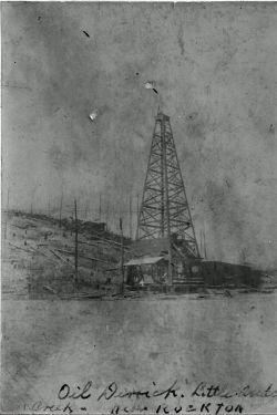
An oil well derrick that once stood in
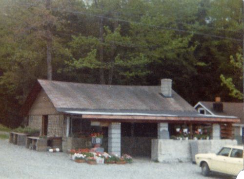
Shaffer Shanty, a farmer’s market style store that was located on the DuBois-Rockton Road was once a popular place to shop.